
 Skip to content
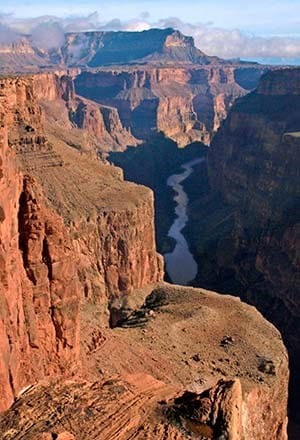
Grand Canyon National Park requires a Backcountry Permit for all campers who wish to stay at the Tuweep Campground.
The Tuweep Campground is the only campground located at the North Rim’s most remote viewpoint: Toroweap Overlook.
The campground has ten campsites: Nine family campsites that each accommodate two vehicles and six people, and One large group campsite that accommodates four vehicles and eleven people.
The Backcountry Permit requirement applies to all ten campsites and ensures that campers know ahead of time that they have a place to stay or if they need to make alternative arrangements.
Information ONLY: (928) 638-7875
Monday – Friday 8am – 5pm
Grand Canyon National Park
Permits Office
1824 S. Thompson St., Suite 201
Flagstaff AZ, 86001
Flat tires are most frequent on smooth, graded sections of roadway hiding unseen fractured, sharp, limestone. Travel slowly, 30 mph (50 kph) or less, to avoid flat tires. Bring tire plugs and a portable air compressor to repair flat tires. Ensure you have enough fuel, full size spare tire, jack/lift, and owner’s manual. Tow service costs $1,000–2,000, and assistance is not guaranteed. Carry extra water, food, and warm clothing. Due to rapidly changing conditions, be equipped to spend the night. During monsoon season, visit in the morning before the afternoon storms. Flooding may occur when the chance of precipitation is as low as 10 percent. During muddy winter conditions, travel when routes are frozen and overnight temperatures below 20°F (-7°C).
Toroweap Overlook: Dramatically different than other Grand Canyon viewpoints, Toroweap Overlook peers out over an abrupt gorge set in a broad corridor 3,000 feet (915 m) below the rim. Eight, million-year-old lava flows and conical black cinder cones stud the landscape. Walk to the edge for a breath-taking experience. To the west, view the largest rapid on nearly 300 miles (485 km) of the park’s Colorado River. Listen carefully for the roar of the river or the faint sounds from boaters below. To the east, enjoy dramatic views.
Tuweep Hiking Trails: Two established hiking trails can be accessed from Tuweep. Their trailheads are signed and cairns (piles of rock) mark their path. Plan ahead for your hike and remember that shade is scarce and water non-existent. All trails are closed to pets, bicycles, and vehicles.
Tuckup Trail: The Tuckup Trail gives hikers a spectacular taste of Esplanade slick-rock on a former prospector’s path. Follow the trail 3 miles (5 km) to Cove Canyon and experience an inner-canyon day hike rewarded with endless views. Access the Tuckup Trailhead north of Tuweep Campground or, if camping, from site 10.
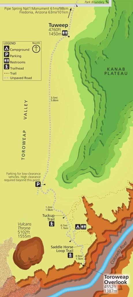
Access the three main routes to Tuweep from AZ 389 between Fredonia, Arizona, and St.George, Utah. Allow two to three hours driving time. Bring the BLM Arizona Strip Visitor Map, and do not rely solely on your GPS unit. Muddy conditions exist during summer monsoons and from winter precipitation.
Sunshine Route: County Road #109, the most reliable route, leaves AZ 389 eight miles (13 km) west of Fredonia or six miles (10 km) east of Pipe Spring National Monument. This 61-mile (98 km) road features sharp rocks, washboarding, and dust. Please do not stop on tribal land when traveling this route.
Clayhole Route: County Road #5 leaves AZ 389 at Colorado City, Arizona. It is 56 miles (90 km) long and impassable when wet.
Main Street Route: BLM Road #1069 and County Road #5 from St. George is 90 miles (145 km) long. This scenic route is impassable in winter due to snow and mud.

469 AZ-64
Grand Canyon, AZ 86023
Copyright © 2024 GrandCanyon.com, Inc.