
The SOUTH RIM – Open 24 hours a day, 365 days a year. Services are available and facilities are open year round.
The NORTH RIM – Visitor services and facilities inside the national park on the NORTH RIM are only open from mid-May to mid-October. Weather permitting; the North Rim is open for day use only following the close of facilities in mid-October. During this time there are no services or overnight facilities available inside the park. The road from Jacob Lake to the North Rim (Highway 67) is subject to closure with little or no notice during this interval and then remains closed until mid-May.
PLANE – Commercial air carriers serve Las Vegas, Phoenix, Flagstaff, and Grand Canyon Airport (in Tusayan, just south of the park).
CAR – Grand Canyon Village (SOUTH RIM) is located 60 miles north of Interstate 40 at Williams via highway 64, and 80 miles northwest of Flagstaff via highway 180. Only ten miles from rim to rim as the crow flies, the North Rim is 215 miles (about 4 1/2 hours) from the South Rim by car. The NORTH RIM is 44 miles south of Jacob Lake, AZ, via highway 67. Visitor services and facilities on the North Rim are only open from mid-May through mid-October.
PUBLIC TRANSPORTATION – SOUTH RIM: Bus Service between Grand Canyon National Park and Flagstaff, Arizona is offered by Nava-Hopi Tours, 800-892-8687, and by South Rim Travel, 928-638-2748. Greyhound Bus Lines offers service from Flagstaff and Williams to points nationwide. Grand Canyon Railroad offers service between Williams and the canyon, 1-800-THE-TRAIN. NORTH RIM: A shuttle service is provided seasonally between the North Rim and the South Rim by Trans-Canyon Shuttle, 928-638-2820. Nearly five million people see Grand Canyon each year. Most of them see it from overlooks along the South Rim, including Grand Canyon Village, Hermits Rest Road, and Desert View Drive. The South Rim, 60 miles/97 km north of Williams and 80 miles/129 km northwest of Flagstaff, Arizona, is the most accessible part of the park and is open all year.
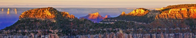
A much smaller number of people see the canyon from the North Rim, which lies just 10 miles/16 km (as the raven flies) directly across from the South Rim. The North Rim rises 1000 feet/305 m higher than the South Rim and is much less accessible. Heavy snows close the North Rim from mid-October to mid-May each year. Even in good weather the North Rim is harder to get to. It lies 220 miles/354 km by car from the South Rim, or 21 miles/34 km by foot across the canyon by way of the North and South Kaibab Trails.
The Inner Canyon includes everything below the rim and is seen mainly by hikers, mule riders, and river rafters. Many opportunities exist here for adventurous and hardy persons who want to backpack, ride a mule to Phantom Ranch, or take a river trip down the Colorado River with many of the popular Grand Canyon River Tours.
How do people get across the Colorado River within Grand Canyon? The South Kaibab Trail crosses the river on a narrow suspension bridge 70 feet/21 m above the water. Only one way across the canyon is accessible by automobile – the Navajo Bridge, located downstream from Lees Ferry, where the canyon is only 400 feet/122 m wide. Nearly five million people see Grand Canyon each year. Most of them see it from overlooks along the South Rim, including Grand Canyon Village, Hermits Rest Road, and Desert View Drive. The South Rim, 60 miles/97 km north of Williams and 80 miles/129 km northwest of Flagstaff, Arizona, is the most accessible part of the park and is open all year.
A much smaller number of people see the canyon from the North Rim, which lies just 10 miles/16 km (as the raven flies) directly across from the South Rim. The North Rim rises 1000 feet/305 m higher than the South Rim and is much less accessible. Heavy snows close the North Rim from mid-October to mid-May each year. Even in good weather the North Rim is harder to get to. It lies 220 miles/354 km by car from the South Rim, or 21 miles/34 km by foot across the canyon by way of the North and South Kaibab Trails.
The Inner Canyon includes everything below the rim and is seen mainly by hikers, mule riders, and river rafters. Many opportunities exist here for adventurous and hardy persons who want to backpack, ride a mule to Phantom Ranch, or take a river trip down the Colorado River with many of the popular Grand Canyon River Tours.
How do people get across the Colorado River within Grand Canyon? The South Kaibab Trail crosses the river on a narrow suspension bridge 70 feet/21 m above the water. Only one way across the canyon is accessible by automobile – the Navajo Bridge, located downstream from Lees Ferry, where the canyon is only 400 feet/122 m wide. The South Rim is 7000 feet above sea level, which means snow in winter and cool nights even in summer. Inner canyon hiking (below the rim) is another story, however: summer temperatures along the Colorado River at the canyon bottom can reach 120º F. The North Rim is 8000 feet above sea level and can receive snow throughout most of the year. Weather is particularly changeable in spring and fall; visitors should be prepared for a variety of climates.
The high altitude of both the South and North Rims may cause visitors with respiratory or heart problems to experience difficulties. All walking at this elevation can be strenuous.
SUMMER – Summer temperatures on the South Rim, at 7000 feet/2134 m, are relatively pleasant (50°s-80°s F/10°s-20°s C). But at 2400 feet/732 m, inner canyon temperatures are extreme. Daytime highs at the river often exceed 100° F/38° C. North Rim summer temperatures are cooler than those on the South Rim due to increased elevation. The North Rim is at 8000 feet/2438 m above sea level.
WINTER – Winter conditions at the South Rim can be extreme. Expect snow, icy roads and trails, and possible road closures. Canyon views may be temporarily obscured during winter storms. In such cases entrance fees are not refundable. The North Rim is closed during the winter.
SPRING & FALL – Spring and fall weather is extremely unpredictable. Be prepared for sudden changes in the weather at those times of year.
